
Table of Contents >> Show >> Hide
- First: What Exactly Is a Hurricane?
- The “Recipe” for a Hurricane: Key Ingredients
- 1) Warm ocean water (the fuel tank)
- 2) Lots of moisture (the storm’s “steam”)
- 3) A pre-existing disturbance (nature needs a starter)
- 4) Low vertical wind shear (don’t tip the stack)
- 5) Enough Coriolis effect (spin class required)
- 6) Atmospheric instability + supportive upper-level winds (room to grow)
- Step-by-Step: How a Hurricane Forms (From “Messy Clouds” to Monster Storm)
- Why Hurricanes Have an Eye (and Why It Feels Like a Plot Twist)
- What Makes Some Hurricanes Rapidly Intensify?
- Where Hurricanes Form (and Why They Don’t Usually Form Near the Equator)
- How Hurricanes Weaken: The Storm’s “Off Switches”
- Common Hurricane Myths (Let’s Retire These)
- Practical Takeaways: How to Think About Hurricane Formation Like a Pro
- of Real-World Experiences Related to Hurricane Formation
Hurricanes don’t “appear” so much as they assemblelike nature’s most dramatic group project, where warm ocean water, humid air, and just the right
winds decide to collaborate. When the ingredients line up, the atmosphere builds a spinning, heat-powered engine that can stretch hundreds of miles across.
The wild part? The same basic physics that makes steam rise off a hot shower also helps power a major hurricane. The difference is… your shower doesn’t have
an eyewall.
First: What Exactly Is a Hurricane?
A hurricane is a type of tropical cyclonea rotating storm system that forms over warm tropical or subtropical ocean waters. In the Atlantic
and Northeast Pacific, we call them “hurricanes.” In other ocean basins, the same kind of storm might be called a “typhoon” or simply a “tropical cyclone.”
The name changes, but the engine is similar: a low-pressure center, bands of thunderstorms, and winds that spiral inward and upward.
Meteorologists categorize these storms by their sustained wind speeds, but it helps to remember that hurricanes are more than wind. They can bring
torrential rain, coastal flooding, dangerous surf, rip currents, and storm surge. In other words: they’re not just “big thunderstorms.” They’re
an organized, rotating system that feeds on ocean heat and moisture.
The “Recipe” for a Hurricane: Key Ingredients
Hurricanes are picky. The ocean and atmosphere must cooperate long enough for a storm to organize and intensify. Here are the big requirements that show up
again and again in hurricane science.
1) Warm ocean water (the fuel tank)
Hurricanes typically need ocean water that’s about 80°F (26.5°C) or warmer, and not just at the surfacewarmth needs to extend down into the
upper ocean. Why? Because the storm churns the water like a giant spoon. If colder water is quickly mixed up from below, the storm can lose its “fuel.”
2) Lots of moisture (the storm’s “steam”)
Warm water evaporates, adding water vapor to the air near the surface. That moisture is crucial because when water vapor condenses into cloud droplets and rain,
it releases latent heatenergy that warms the surrounding air and helps it rise even more. This rising-and-condensing cycle is the heart of the
hurricane’s power source.
3) A pre-existing disturbance (nature needs a starter)
Hurricanes rarely start from a blank sky. They often begin as a tropical wave or another cluster of thunderstorms that already has some
organizationjust enough to create a weak, broad area of lower pressure and converging winds near the surface.
4) Low vertical wind shear (don’t tip the stack)
Wind shear is how much wind speed and/or direction changes with height. Too much shear can tear storms apart by tilting the developing circulation.
Hurricanes like their structure “stacked” verticallysurface low, rising air, and outflow aloft lined up like a neat column. Strong shear makes that column lean,
and leaning storms struggle to intensify.
5) Enough Coriolis effect (spin class required)
Hurricanes need Earth’s rotation to help organize a broad spin. That’s why they rarely form very close to the equatorthere isn’t enough Coriolis force there to
encourage large-scale rotation. Farther from the equator, air flowing toward low pressure gets deflected, helping the system begin rotating.
6) Atmospheric instability + supportive upper-level winds (room to grow)
Rising air needs to keep rising. If the atmosphere is stable (like a lid on a pot), thunderstorms can’t build and persist. Hurricanes also benefit from
upper-level outflowwinds high in the atmosphere that vent air away from the storm’s top, helping surface pressure drop and sustaining the inward flow near the ocean.
Step-by-Step: How a Hurricane Forms (From “Messy Clouds” to Monster Storm)
Step 1: Warm water boosts evaporation and thunderstorms
Over warm tropical ocean water, evaporation loads the lower atmosphere with moisture. When surface winds converge (flow together), air is forced upward.
As it rises, it cools, and water vapor condenses into clouds and rain. Condensation releases heat, warming the surrounding air, which rises fasterencouraging
more thunderstorms. Think of it like an atmospheric feedback loop with a caffeine addiction.
Step 2: A low-pressure center starts to form
As rising air accelerates and spreads out near the top of the storm, surface pressure below can drop. Lower pressure at the surface encourages more air to rush
in from the surroundings. That inflow strengthens the convergence, which strengthens the thunderstorms, which lowers pressure more. It’s a loop, and it’s
surprisingly good at turning ocean heat into wind.
Step 3: Rotation organizes (hello, spin)
Once the developing system is far enough from the equator, Coriolis deflection helps the inflowing air curve, building a rotating circulation. As the storm organizes,
the rotation becomes more coherent around a center. Bands of thunderstorms begin wrapping around the low-pressure core like a cinnamon roll made of clouds.
Step 4: Tropical Depression → Tropical Storm
When meteorologists identify a closed circulation with organized thunderstorms, the system can be classified as a tropical depression.
If winds strengthen enough (sustained winds reach tropical-storm strength), it becomes a tropical storm and typically gets a name.
At this stage, the storm is still “figuring itself out,” but the engine is running: warm ocean + moisture + condensation heat + organized inflow.
Step 5: The storm becomes a hurricane (warm-core powerhouse)
If conditions stay favorablewarm water, humid air, and low wind shearthe storm can intensify into a hurricane. The system becomes more symmetrical,
the pressure drops further, and winds accelerate around the center. Hurricanes are called warm-core storms because the release of heat in
thunderstorms warms the middle of the storm compared with the surrounding environment, reinforcing the low pressure and circulation.
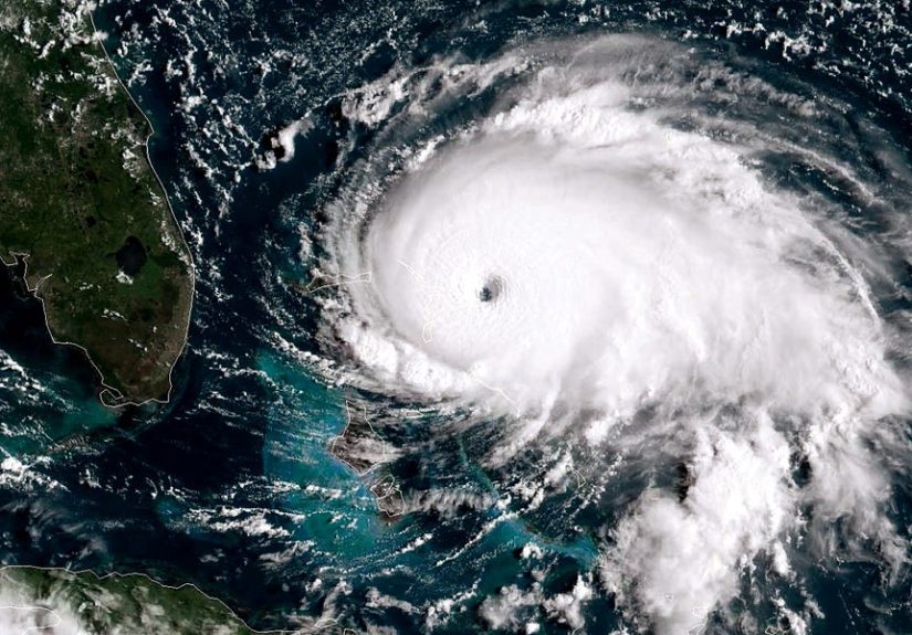
Why Hurricanes Have an Eye (and Why It Feels Like a Plot Twist)
The eye is the relatively calm, often clearer center of a strong hurricane. Surrounding it is the eyewalla ring of intense thunderstorms
with the storm’s strongest winds and heaviest rain. The eye forms as the storm’s rotation tightens and the strongest rising motion concentrates in the eyewall.
Inside the eye, air tends to sink, which suppresses clouds and creates calmer conditions.
If you’ve ever heard stories like “It got weirdly calm, then it got worse again,” that’s often an eye passage. The calm can be misleadingbecause the eyewall on the other side
can arrive quickly and with winds from a different direction. It’s the meteorological equivalent of “This isn’t even my final form.”
What Makes Some Hurricanes Rapidly Intensify?
Sometimes a storm strengthens gradually; other times it “levels up” fast. Rapid intensification is more likely when several helpful factors stack together:
- Very warm ocean water with deep heat content (so mixing doesn’t immediately pull up cold water).
- Moist air in the middle levels of the atmosphere (dry air can weaken thunderstorms).
- Low wind shear, allowing the storm’s core to stay vertically aligned.
- Efficient outflow aloft that “vents” the storm like a chimney, helping pressure fall.
A real-world example: hurricanes that pass over unusually warm waters in the Gulf of Mexico or Caribbean Sea can intensify quickly when wind shear stays low.
This is one reason hurricane forecasts focus so much on ocean temperatures, heat content, and upper-level wind patternsnot just where the storm is today,
but what environment it’s moving into next.
Where Hurricanes Form (and Why They Don’t Usually Form Near the Equator)
Hurricanes typically form over warm waters in the tropics and subtropics, often between about 5° and 20° latitude. Near the equator, the Coriolis effect
is too weak to help a storm organize a large-scale spin, so true tropical cyclones are uncommon there.
The Atlantic hurricane season runs from June through November, with peak activity often late summer into early fall, when ocean waters are warmest.
Other basins have their own seasonal patterns, but the common thread is warm water plus an atmosphere willing to cooperate.
How Hurricanes Weaken: The Storm’s “Off Switches”
If hurricanes are powered by warm water and organization, then weakening happens when that power is cutor the organization gets disrupted.
Moving over land
Land removes the storm’s warm-water fuel source and adds friction that disrupts circulation. Mountains can also shred the storm’s structure.
Cooler water or ocean upwelling
Over cooler sea surface temperatures, evaporation decreases and the storm’s heat engine weakens. Even over warm areas, hurricanes can churn up cooler water from below
(upwelling), which can reduce intensity.
High wind shear or dry air intrusion
Strong wind shear can tilt the storm and separate thunderstorms from the circulation center. Dry air can also suppress thunderstorms, weakening the storm’s core.
Common Hurricane Myths (Let’s Retire These)
“Hurricanes are just strong wind storms.”
Wind is a major hazard, but hurricanes also produce flooding rain, storm surge, and dangerous surf. Many of the most serious impacts come from water, not just wind.
“A hurricane needs an eye to be dangerous.”
Plenty of storms cause severe flooding and wind damage before a clear eye forms. Structure can evolve rapidly, and impacts can happen far from the exact center.
“If it’s not Category 5, it’s fine.”
Category ratings are based on wind speed, but rainfall and storm surge don’t follow a neat category-only script. Some lower-category storms have produced catastrophic flooding.
Practical Takeaways: How to Think About Hurricane Formation Like a Pro
If you want the “one-sentence” explanation: a hurricane forms when a pre-existing disturbance over very warm water organizes thunderstorms, releases heat through condensation,
lowers pressure, pulls in more air, and spins up into a self-reinforcing systemso long as wind shear and dry air don’t wreck the setup.
Or, in friendlier terms: warm ocean + humid air + thunderstorms + spin + calm upper winds = storm that can grow into a hurricane. Take away any of those,
and development becomes harder.
of Real-World Experiences Related to Hurricane Formation
You can read a perfect explanation of how a hurricane forms and still feel surprised the first time you watch one develop in real timebecause it doesn’t look like a textbook diagram.
It starts as “just” messy weather: scattered thunderstorms popping up and fading, bursts of rain offshore, a blob on radar that looks more like spilled ink than a future headline.
For meteorologists, that early stage is a mix of science and suspense. They’re watching sea surface temperatures, wind shear charts, satellite loops, and those subtle signs of organization:
clouds beginning to curve, thunderstorms clustering near a developing center, and outflow aloft starting to fan outward like a wispy pinwheel.
For people living along the coast, the experience is often quieter at firstalmost annoying. The ocean is warm, the air feels heavy, and the forecasts start using phrases like
“increased chance of development.” That’s when routines kick in: checking supplies, charging devices, cleaning yards, and watching updates. There’s a strange psychology to it.
A forming hurricane isn’t “here” yet, but it begins to influence your day anywaylike an uninvited guest who keeps texting “On my way” and you’re not sure if they mean five minutes or five hours.
As a storm organizes into a tropical storm and then a hurricane, people often describe the sky looking layered and fast-moving, with bands of rain that come and go in waves.
Those rain bands are part of the storm’s structureevidence that the circulation is tightening and the system is feeding more efficiently on warm ocean moisture.
A common experience is noticing the wind shift direction over time. That’s the rotation becoming more apparent at the surface, and it can be a clue that the storm’s center is drawing nearer.
Even far from landfall, beaches can turn rough as the storm’s energy travels outward, making rip currents and surf dangerous long before the “main event.”
If someone experiences the eye of a well-formed hurricane, they often say it feels unreal: after hours of roaring wind and driving rain, it can suddenly become calmer,
sometimes with a brighter patch of sky overhead. The calm can tempt people to step outside, but the second half of the storm can arrive quicklywith winds from the opposite direction.
It’s one of the clearest “in-person” reminders that hurricanes are organized rotating systems, not a single uniform blast of weather.
Afterward, many people talk about the same lesson: hurricanes are built from basics you can understandwarm water, moisture, and wind patternsbut their impacts depend on timing, track, and local geography.
The formation story becomes personal when you realize that what starts as warm ocean evaporation can end up as days of rain, power outages, or flooded streets. That’s why respecting the science matters:
understanding how hurricanes form isn’t just triviait’s a way to take forecasts seriously and make smarter decisions when the atmosphere starts “cooking.”